|
|
|
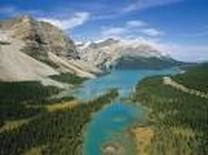
This optional theme focusses on freshwater ( scare resource water on the land ). It considers human's impact on water quality and the ways in which human's respond to the challenges of managing the quantity and quality of freshwater. This theme explains the positive and negative consequences of water management.
Precipitation - the transfer of moisture to the earth's surface from atmosphere.
Interception - the capture of raindrops by plant cover.
Runoff - precipitation that does not soak into the ground but flows over it into surface waters.
Groundwater - water held underground in soil or rock often feeding wells.
Evapotranspiration - the loss of water from vegetation and water surface to the atmosphere.
Potential evapotranspiration - the rate of water loss from an area if there were no shortage of water.
Maximum sustainable yield - the maximum level of extraction of water that can be maintained indefinitely for a region.
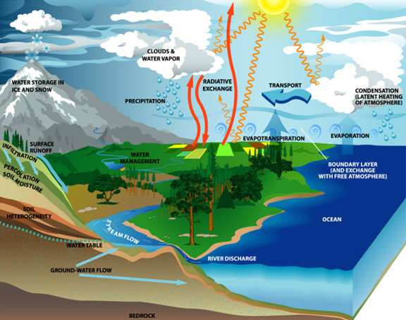
The global hydrological cycle
The global hydrological cycle is the transfer of water between sea, air and land. It comprises evaporation from oceans, water vapour, condensation, precipitation, runoff, groundwater and evapotranspiration.
Evaporation:This is the transformation of water into it's gas form. Vapour. This is a result ofvapor pressure, air temperature, wind and rock surfaces since these have higher evaporation rates the other surfaces.
High rates of evaporation are recorded in hot deserts if there was no shortage of water in the first place. The evaporation rates are much lower in tropical rand forests and in cold areas, due to the high humidity rate in the air and due to the high amount of water and vegetation in such areas.
Condensation: Condensation is the process of a gas becoming a liquid. so basically the transformation from vapour into water. This process occurs when the steam or the vapour hits or comes in contact with a cool surface or cool air and condensates. through further cooling the vapour could turn into water and from water into snow or frost.
Interception: Interception is the process of water hitting other surfaces then the ground like plants and vegetation (stem flow). This prevents them from reaching the found and will evaporate from there then instead of the ground.
- Infiltration: is the process in which the water sinks into the ground.
- infiltration rate: is the speed in which water travels into the ground / soil
- Infiltration capacity: is the amount of water the soil can hold.
- Percolation: is when water sinks deep into the ground into the groundwater zone.
- overland runoff: occurs when the ground is full with water already and the water has nowhere to go except to runoff.
- water table: divides the groundwater zones
- Aquifers: rocks which hold water
- Zone of Aeration: Is a transitional zone in which water passes through upwards or downwards.
- Overland flow: when precipitation exceeds the infiltration rate, Or when the soil is saturated ( when all pore spaces are already filled with water)
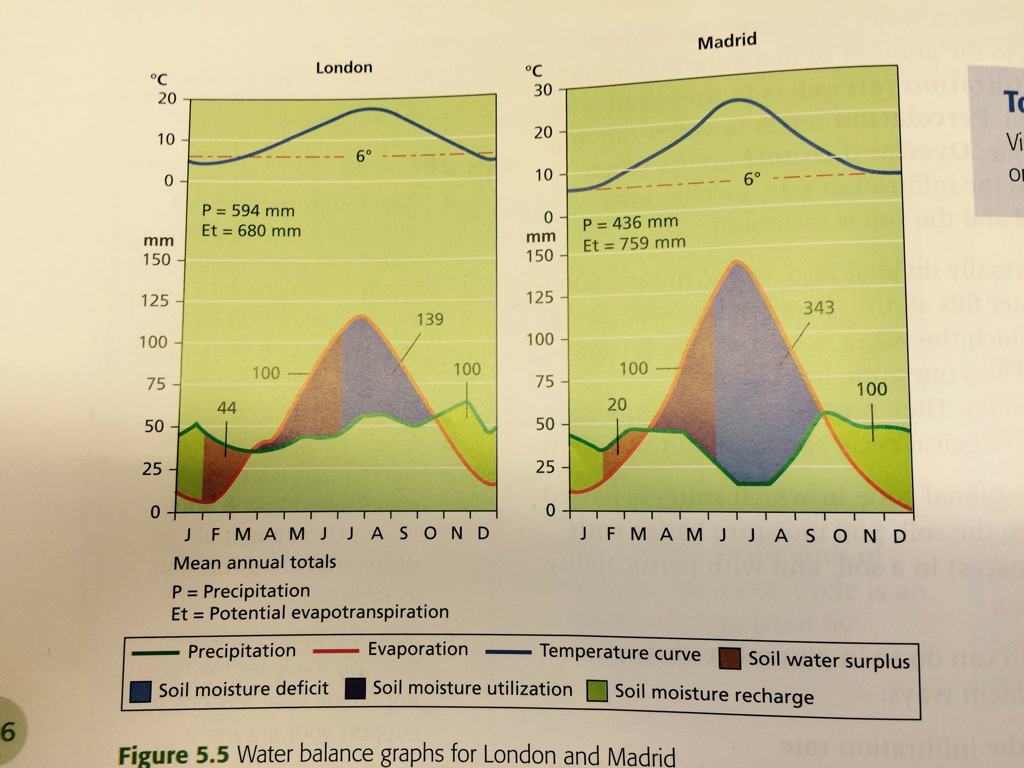
The water balance
The water balance is the relationship between the inputs and outputs in a drainage basin.
P= Q +/- E (Precipitation= runoff +/- evapotranspiration)
Soil moisture deficit is degree to which soil moisture falls below field capacity.
Soil moisture recharge occurs refilling of water in the dried-up pores of the soil.
Soil moisture surplus is the period when water can not enter in soil and flows over the surface.
Soil moisture utilization is the process where water is drawn to the surface and may be used by plants or evaporated.
Discharge, stream flow and channel shape
Discharge is the volume of water passing a given point over a set time. It increases downstream in width, depth and velocity. It is normally expressed in cubic metres per second, or m3/sec.
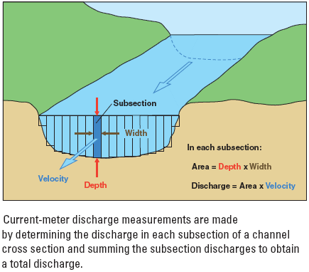
Velocity - spead of river in a given direction. It varies with a number of factors: volume of water, roughness of bed, gradient of stream, and width, depth and shape of channel. Water closes to the bank is much slower than water in the center.
Channel shape - the efficiency of a stream's shape is measured by its hydraulic radius (the cross-sectional area divided by wetted perimeter).
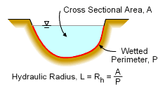
The shape of the channel is also determined by the material forming the channel and river forces. Solid rocks allows only slow changes but alluvium allows rapid changes.
Channel roughness - it causes friction which slows down the velocity of the river. Friction is caused by irregularities in the riverbed, boulders, trees and vegetation, and contract between the water and the bed and bank.

v=velocity ; R=hydraulic radius ; S=slope ; n=roughness
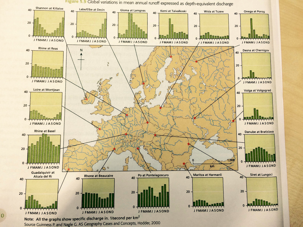
River regimes
The river regime is the seasonal variation in the flow of a river caused by many factors such as:
- the amount of precipitation
- temparatute changes and evapotranspiration
- changing in vegetation
- shape and size of the drainage basin and also variations in rock and soil types
Storm hydrograph - a way of displaying how the discharge of a river can change over time in the hydrological cycle. It measures the speed of rain falling on a dranage busin reaches the river channel.
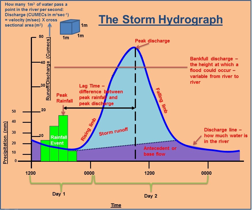
Rising limb
Lag time
Runoff curve
Normal flow (base flow)
Recessional limb
Hydrograph size
- Shows the amount of discharge and the speed of increasing
- Very steep in a flash flood or in a small drainage basin where the responce is rapid
- Steep in urbanized catchments
- Higher in larger basins
- Steep catchments have lower infiltration rates
- Flat catchments have high infiltration rates
Lag time
- Time interval between peak rainfall and peak discharge
- Basin shape, steepness and stream order have influence on it
Runoff curve
- Relationship between overland flow and throughflow
- Overland flow dominate where is low infiltration, high moisture, impermeable surface and strong rainfall
Normal flow (base flow)
- The seepage of water into the channel
- A slow movement with a long-term supplier of the river's discharge
Recessional limb
- Influenced by aquifers
- Larger catchments have less steep recessional limbs
Hydrograph size
- The higher the rainfall the greater the discharge
- The larger the basin size the greater the discharge
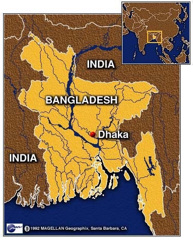
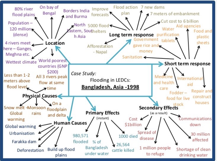
The case study - Bangladesh (flooding) 1998
Reffering to specific case studies, discuss the factors affecting river flooding.
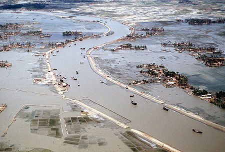
Bangladesh is a really poor country (one of the poorest) and the most densely populated country. In Bangladesh there is a rapid pupulation growth (2.7% increasing a year).
Country was formed by deposition of 3 largest rivers :
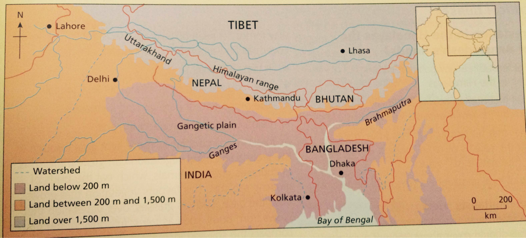
These rivers form one of the largest deltas in the world (80% of country is located on delta) so it means much of the country is a few metres above the sea. All Bangladesh rivers have their source outside the country. Brahmaputra covers 1.75 million m2 which include :
75% of annual rainfall occurs between June and September while summer monsoon is active. During the monsoon, 30-50% of country is flooded. he Ganges and Brahmaputra carry melted snow and ice from Himalayas. They also carry sediment which is deposited annualy and form temporary islands and sandbacks. It also help fertilize the land.
Country was formed by deposition of 3 largest rivers :
- The Brahmaputra
- The Ganges
- The Meghna
These rivers form one of the largest deltas in the world (80% of country is located on delta) so it means much of the country is a few metres above the sea. All Bangladesh rivers have their source outside the country. Brahmaputra covers 1.75 million m2 which include :
- Himalayas
- The Tibetan Plateau
- The Northen India
75% of annual rainfall occurs between June and September while summer monsoon is active. During the monsoon, 30-50% of country is flooded. he Ganges and Brahmaputra carry melted snow and ice from Himalayas. They also carry sediment which is deposited annualy and form temporary islands and sandbacks. It also help fertilize the land.
Advantages of the floods
Disadvantages of the floods
- Replenish ground water reserves
- Provide nutrient-rich sediment for agriculture in dry seasons
- Provide fish (food)
- Reduce the need of artificial fertilizers
- Flush pollutants and pathogens away from domestic areas
Disadvantages of the floods
- Discharge peaks of the big rivers
- High runoff from the Meghalaya Hills
- Heavy rainfall associated with the monsoon
- High groundwater tables
- Spring tides
- Lateral river embankments
- The disappearance of natural water storage areas in the lowlands
- Snow melt in the Himalayas
There are 5 main flooding types in Bangladesh:
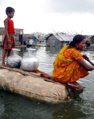
Human activity has also increased the problem. Attempts to reduce flooding by building embankments and dikes have prevented the back-flow of floodwater into the river. This leads to a ponding of water and back-flooding. Embankments have sometimes led to an increase in deposition in drainage channels and this can cause large-scale deep flooding. In this country coastal flooding is also known. Storm surges are caused by low-pressure systems are funneled up the Bay of Bengal to the delta. Bangladesh is one of the most vulnerable countries to climate change. As sea levels rise and extreme weather events become more common.
- River floods
- Overland runoff
- Flash floods
- "Back flooding"
- Storm surges
Human activity has also increased the problem. Attempts to reduce flooding by building embankments and dikes have prevented the back-flow of floodwater into the river. This leads to a ponding of water and back-flooding. Embankments have sometimes led to an increase in deposition in drainage channels and this can cause large-scale deep flooding. In this country coastal flooding is also known. Storm surges are caused by low-pressure systems are funneled up the Bay of Bengal to the delta. Bangladesh is one of the most vulnerable countries to climate change. As sea levels rise and extreme weather events become more common.
Impacts of the worst flooding in Bangladesh 1998:
- 4 750 people were killed
- 23 million people lost their home
- 130 000 cattle died
- 660 000 hectares of crops were damaged
- 400 factories were closed
- 11 000 km of roads were damaged
- 1 000 schools were damaged or destroyed
|
|
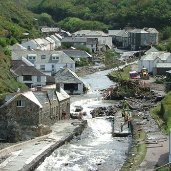
The case study - Boscastle flood
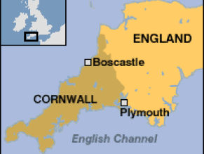
A small town on the south of England, very popular with tourists, was hit by catastrophic floods on 16th of August 2004.
Causes:
Human causes:
Effects:
- The runoff from the mountain range was too high
- Heavy rainfall during the monsoon time
- River banks were too lateral which made water to overflow
- Over 60mm of rainfall fell in 2 hours on already saturated land
- Dissapearance of water intraceptions through urbanization
Human causes:
- Lack of any food control
- Old sewer and drainage system with low capacity
- Small, low bridges over river trapped material and cars causing water to flow round the brigde causing more flooding
Effects:
- 25 business properties destroyed
- 50 buildings damaged
- 4 footbridge washed away
- Pavements and gardens damaged by weight of water
- Roads blocked so rescue by helicopter only
- Visitor center destroyed and mug covered large parts of the town
Flood defence:
- Widening channel and lowering bed by 0.7 m to increase discharge capacity
- Raising car park to work as flood defence and make cars safer
- New flood wall to reduce impact
- Clearing vegetation from river bed
- Drainage improvements
- It cost £4.6 million and complited by 2008
Referring to specific case studies, discuss the factors affecting river flooding.
This essay is going to precisely explain and show us factors affecting river flooding referring to specific case studies of Bangladesh and Boscastle. There are many factors that can affect river to over-flood. The main factors affecting flooding are steepness, saturated soil, runoff, shape and depth of river channel, saturated river regime with massive amount of rainfall carrying particle and material downstream and deforestation which is connected with soil erosion. I will examine the reasons why these factors are affecting rivers to over-flood referring to the real world's examples.
Steepness is one of the factors that can affect river flooding. The position of the river is downstream the mountain where the ground is really steep and rocky. A huge amount of runoff fell down on the ground and connect to the river regime. In the spring a lot of ice and snow melted water from mountain come into the same regime which can be overloaded with water. River's velocity decrease rapidly and it is more powerful to carry heavy rocks and trees that can be found in the river. While water from runoff and melted snow are filling the river channel, it reaches the peak discharge. The explanation of the peak discharge is the highest possible level of river that reach the maximum hight in the channel not to overflow the river sides. If the level continue rising it will cause floods.
Other factor that causes floods is deforestation. This is human's impact on environment and its vegetation changes. Cutting a huge number of trees in one place can affect soil in a bad way-erosion. Erosion is defined as the transfer of soil or rocks from one place to another where is accumulated. Roots of the trees are holding soil in one position and when the trees are gone, soil is not held by anything. The huge amount of runoff fell on the ground. Runoff is precipitation that does not soak into the ground but flows over it. Saturated soil spread water all around the surface and it is keeping there which make floods. Other way of erosion is water flow in river. It can cause erosion and river enlargement in both sides. River is finding the best way to go and makes meanders in curve areas. Water energy is taking part of soil from one side (depends in which side curve is). By the time, water will enlarge more and make floods in near environment.
The position of the discharge can also cause floods. There are two types of catchments in discharge, steep and flat. Steep catchments have lower infiltration rates whilst flat have high infiltration rates. On steep discharges water go downstream with a huge amount of energy to a flat area. If the amount of discharge is high, the velocity of water is high as well but if the amount of discharge is very low, the speed of the river is not that fast. The narrow and shallow rivers over-flood much quicker than deeper and wide rivers. The higher the rainfall, the greater the discharge.
Therefore river regimes can also cause terrible floods. From the transpiration to the moisture in the air, through rainfall water is filling river regimes. Huge amount of runoff increase river's energy which make it carry heavy rocks, trees, and basically everything on its way. Those particles can block the channel of the river and make a barrier that can cause whole water to accumulate on one place until water starts to overrun over river sides and its barriers which cause floods. River regime need to be passable all the time.
In 1998 terrible floods happened in a little mid-east country, Bangladesh. This country is formed by deposition of the 3 largest rivers The Brahmaputra, The Ganges and the Meghna. Bangladesh is just a few meters above the sea level. 75% of the annual rainfall occurs between June and September while summer monsoon is active. From the highest range of mountains, Himalayas, water is coming from melted snow and ice by the Brahmaputra and the Gangs. These rivers are carrying sediment which is deposited annually and it helps fertilize the land. While terrible runoff in the summer, heavy monsoon causes peak discharges in the major rivers during June and July. This leads to serious flooding and destruction of agricultural land. The effects of floods have intensified by the destruction of forest which reduces interception and increase the rate of surface runoff. Floods have killed approximately 5,000 people and 23 million of people were homeless. Roads, buildings and schools were damaged and destroyed. 600,000 hectares of agricultural lands with crops were damaged. These floods caused a huge spread of diseases, turned down communication through country, stopped transport, and destroyed a lot of buildings and people houses. This floods costs Bangladesh about $1billion.
On 16th of August 2004 catastrophic floods was hit small town Boscastle on the south of the England. This floods was caused by the too high runoff from the mountain range. During the monsoon time it was heavy rain which caused water from the river to overflow river banks. These floods had a massive effects on this little town. Over than 60 buildings are either damager or destroyed, footbridges were washed away, roads were blocked so medical care and rescuing were done by helicopter. This disaster costs government £4.6 million.
This essay has examined and shown us factors witch causes floods. Through Case studies, world's real examples, I have examined the impacts caused by floods. Bangladesh and Boscastle had terrible floods that made damages and killed people. Floods are very dangerous disasters, they are destroying everything in front of them. This investigation has explained and examined how they form and which causes they bring.
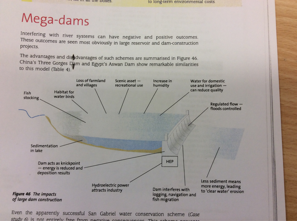
Management issues and strategies
- Mega-dams
Conflict over the Mekong dams:
The Mekong river flows through five countries from China to Vietnam. China's upstream dam provides HEP(hidro-electric-power) and water. The second dam at Dachaoshan should be fimished in 2012. There are 8 more dams planned to built on the river Mekong. The flow of the river in Laos have been reduced considerably and fish stocks are decling rapidly, which sypport 1.5 million people. The Nam Theun Dam in Laos will displace over 5000 people. It costs government US$1.1 billion. In 20 years, Mekong river could be changed from being a relatively untouched to one of the most dammaed in the world.
The Mekong river flows through five countries from China to Vietnam. China's upstream dam provides HEP(hidro-electric-power) and water. The second dam at Dachaoshan should be fimished in 2012. There are 8 more dams planned to built on the river Mekong. The flow of the river in Laos have been reduced considerably and fish stocks are decling rapidly, which sypport 1.5 million people. The Nam Theun Dam in Laos will displace over 5000 people. It costs government US$1.1 billion. In 20 years, Mekong river could be changed from being a relatively untouched to one of the most dammaed in the world.
- Changes to the hydrology upstream of dams
An increase in the amount of surface store (reservoirs are an artificial store).
A reduction in the velocity of the river upstream. The river was effectively flowing into a stationary store of water.
Increased sedimentation can lower the depth of the river and the reservoir. Again this will reduce velocity and may also reduce storage capacity.
- Changes to the hydrology downstream of dams
River discharge will decrease because water is being held behind the dam.
A rivers’ discharge may become more regular (less extremes) because the flow of water is regulated.
Clear water erosion may cause the bed of the river to lower. There is no sediment (load) to be deposited to replace erosion.
The amount of load transported by the river will reduce because less sediment is reaching downstream.
The salinity of the water and the ground may increase.
The temperature of the water may reduce, as water released from reservoirs is often colder (reservoir deeper than river).
The water may also be less oxygenated than natural free flowing water.
With smaller discharge the velocity of the river may decrease, because the level of the river is further below bank-full discharge so the hydraulic radius is smaller.
The amount of depositional landforms may reduce e.g. alluvial fans, levees, deltas and slip off slopes.
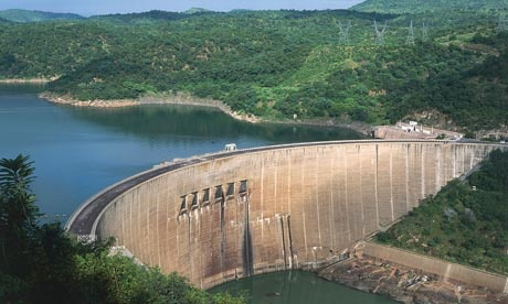
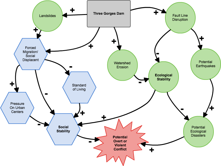
Three Gorges Dam
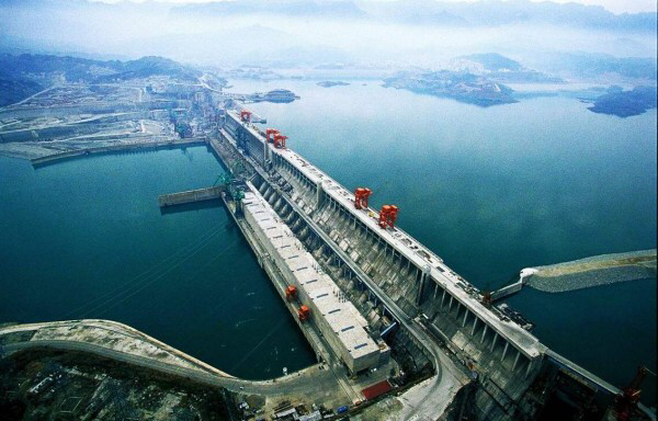
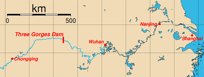
Three Gorges Dam is the biggest dam in the world. It spans the Yangtze river from the town Sandouping in Hubei province of China. This dam is the largest hydroelectric facility in terms of energy generation per a year.
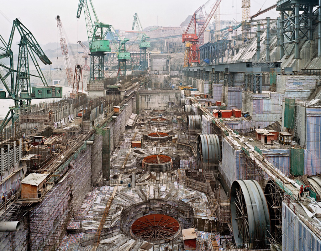
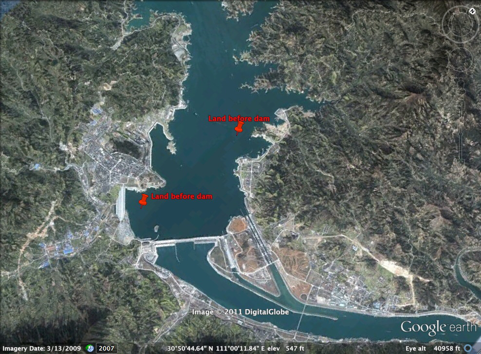
This picture shows dam before they finished all working
How is the Three Gorges Dam multi-purpose scheme ?
The Three Gorges Dam is multi-purpose dam because it has been built for many reasons. It cost China $59 to built. The project produces hydroelectricity, increases river's navigation capacity and reduces the potential for floods downstream by providing flood storage space. It generates 11 times as much power as the Hoover Dam. It is long 2.3 kilometer and it creates a lot of energy for the province around. This dam is 180 meters in height and has a reservoir that stretches 1000 square kilometers. The reservoir helps control flooding on the Yangtze River basin and allows 10 000 ocean freighters to sail into the interior of China six months out of the year.
This dam also provides irrigation, which is also useful for province because it is mainly agricultural and it needs water to irrigate agricultural areas. Overall, this dam has a lot of purposes and it provides a lot of water for the province.
The benefits of the Three Gorges Dam
- Social: The main social benefit is that this dam has provided thousands of jobs for people and it provides faster transport for those who have boats. Other advantage is hydroelectricity, which dam provides to all population of China.
- Economic: The dam generates 20 000 megawatts which means that the cost of coal is reduced and since September 2009, the dam has generated 350 tWh of electricity, covering more than one third of its project cost. There is also benefit in tourism, by boat tours through the dam and China's economy will rise faster.
- Environmental: HEP is renewable source of energy and it will be always active until the water of the river disappear. This dam has huge impact on flooding and it controls water flow downstream and protect over 10 million people from flooding.
- Political: This part of China tends to use renewable and clear source of energy and its reputation has increased rapidly. China doesn't depend on others, it has its own energy which will provide people more stability and no fear in future.
The disadvantages of the Three Gorges Dam
- Social: More than million people has been removed because of the dam to pass and it forced people to migrate from the ares where the dam has been built.
- Economic: This dam costed China fortune, $59 billion which represent one of the most expensive dams in the world.
- Environmental: It caused floods below the region where Three Gorges Dam was built and it also caused a landscape loss. This part of China is seismically unstable.
- Political: It help government to have renewable source of energy and some of the archeological treasures were found while its building.
Fluvial erosion and transport
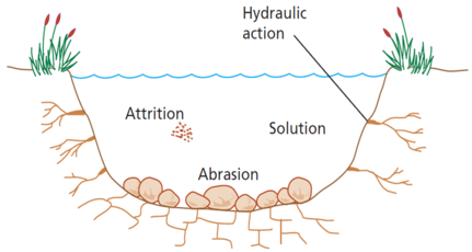
Erosion: Involving the wearing away of rocks and soil found along the river bed and banks. First type of fluvial erosion is attrition. In this type of erosion rocks are being carried by the river smash together and break into smaller, smoother and rounder particles. Second type of fluvial erosion is hydraulic action. In hydraulic action the force of the river against the banks can cause air to be trapped in cracks. The pessure weakens the banks and gradually wears it away. Thirs type of fluvial erosion is solution where soluble particles are dissolved into the river. In the last fluvial erosion, abrasion, rocks are being carried along by the river wear down the river bed and banks.
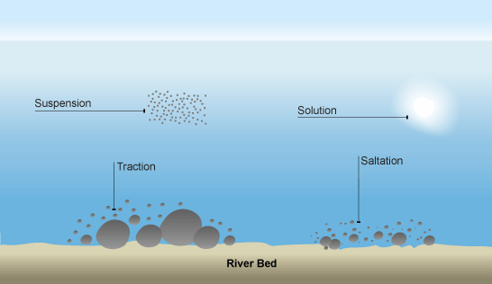
Transportation: River is picking and carrying material as they flow downstream. First process is solution. In this process minerals are dissolved in the water and carried along in solution. Second process is suspension in which fine light material is carried along in the river. Third process is saltation in which small pebbles and stones are bounced along the river bed. The last process is traction in which large boulders and rocks are rolled along the river bed.
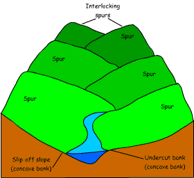
UPPER COURSE
As the river moves through the upper course it cuts downwards. The gradient here is steep and the river channel is narrow. Vertical erosion in this highland part of the river helps to create interlocking spurs, rapids and waterfalls.
As the river moves through the upper course it cuts downwards. The gradient here is steep and the river channel is narrow. Vertical erosion in this highland part of the river helps to create interlocking spurs, rapids and waterfalls.
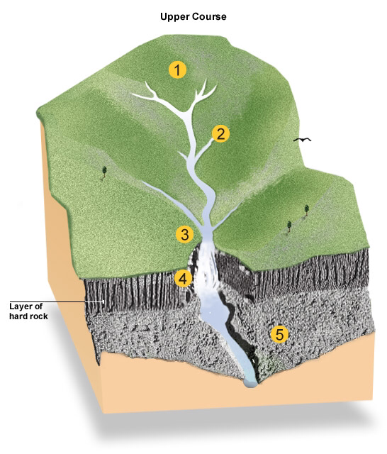
- Interlocking spurs: as the river erodes the landscape in the upper course, it winds and bends to avoid areas of hard rock. This is how interlocking spurs are created.
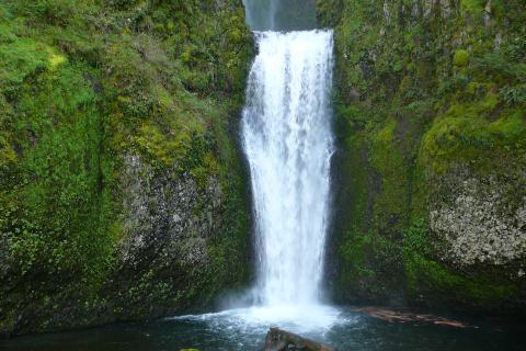
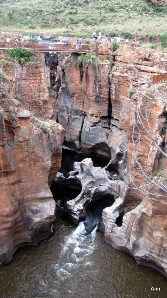
- Waterfalls: when a river runs over alternating layers of hard and soft rock, waterfalls and rapids may form. Waterfalls are where water descends vertically. Waterfalls are usually created by a change in rock type. As the river moves from hard rock to soft rock, erosion increases creating a waterfall. As the water falls over the waterfall it erodes the river bed and the bottom of the waterfall. This makes a plunge pool and causes some undercutting. The undercutting creates an overhang which will eventually become too heavy to be supported and collapse into the plunge pool. The whole process then starts again, which means the waterfall is constantly retreating upstream towards the source. As the waterfall retreats it leaves behind a gorge. Gorge is a deep sided valley left behind when a waterfall retreats.
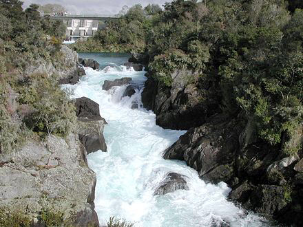
- Rapids: Rapids are sections of rough turbulent (white water) water. They are normally in a river's upper course and are formed when you get layers of hard and soft rock. The layers of soft rock erode quicker than the layers of hard rock. This makes the bed of the river uneven creating rough turbulent water.
Rapids can become popular with tourists who want to raft down them. Some of the most popular rafting rivers are the Nile in Uganda and the Zambezi in Zimbabwe.
However, rapids can cause problems with transport, ships can not travel up and down rapids and it is very hard to build bridges across them. They are also extremely dangerous if people fall into them.
- Potholes: Potholes are cylindrical holes drilled into the bed of a river that vary in depth & diameter from a few centimetres to several metres. They’re found in the upper course of a river where it has enough potential energy to erode vertically and its flow is turbulent. In the upper course of a river, its load is large and mainly transported by traction along the river bed.
MIDDLE COURSE
In the middle course the river has more energy and a high volume of water. The gradient here is gentle and lateral (sideways) erosion has widened the river channel. The river channel has also deepened. A larger river channel means there is less friction, so the water flows faster.
In the middle course the river has more energy and a high volume of water. The gradient here is gentle and lateral (sideways) erosion has widened the river channel. The river channel has also deepened. A larger river channel means there is less friction, so the water flows faster.
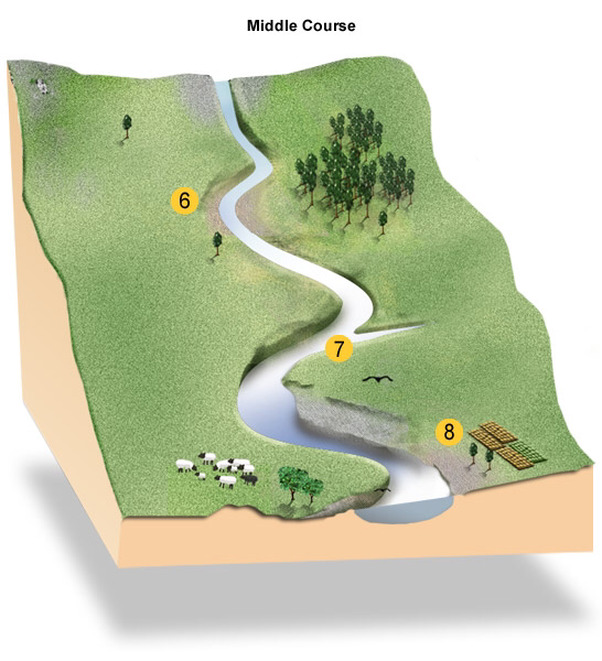
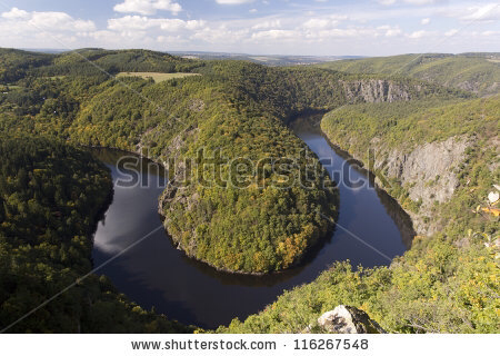
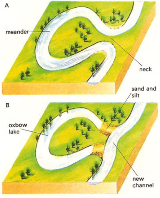
- Meanders: Meanders are bends in a river that form as a river’s sinuosity increases. The sinuosity of a river is a measurement of how much a river varies from a straight line. It’s a ratio between the channel length and displacement (straight line distance) between two points in the river’s course.
LOWER COURSE
In the lower course, the river has a high volume and a large discharge. The river channel is now deep and wide and the landscape around it is flat. However, as a river reaches the end of its journey, energy levels are low and deposition takes place.
In the lower course, the river has a high volume and a large discharge. The river channel is now deep and wide and the landscape around it is flat. However, as a river reaches the end of its journey, energy levels are low and deposition takes place.
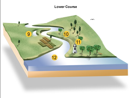
- Oxbow lakes: over time the horseshoe become tighter, until the ends become very close together. As the river breaks through, eg during a flood when the river has a higher discharge and more energy, and the ends join, the loop is cut-off from the main channel. The cut-off loop is called an oxbow lake.
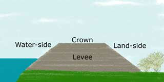
- Levees: The river now has a wide floodplain. A floodplain is the area around a river that is covered in times of flood. A floodplain is a very fertile area due to the rich alluvium deposited by floodwaters. This makes floodplains a good place for agriculture. A build up of alluvium on the banks of a river can create levees, which raise the river bank.
Human modification of a flood plain
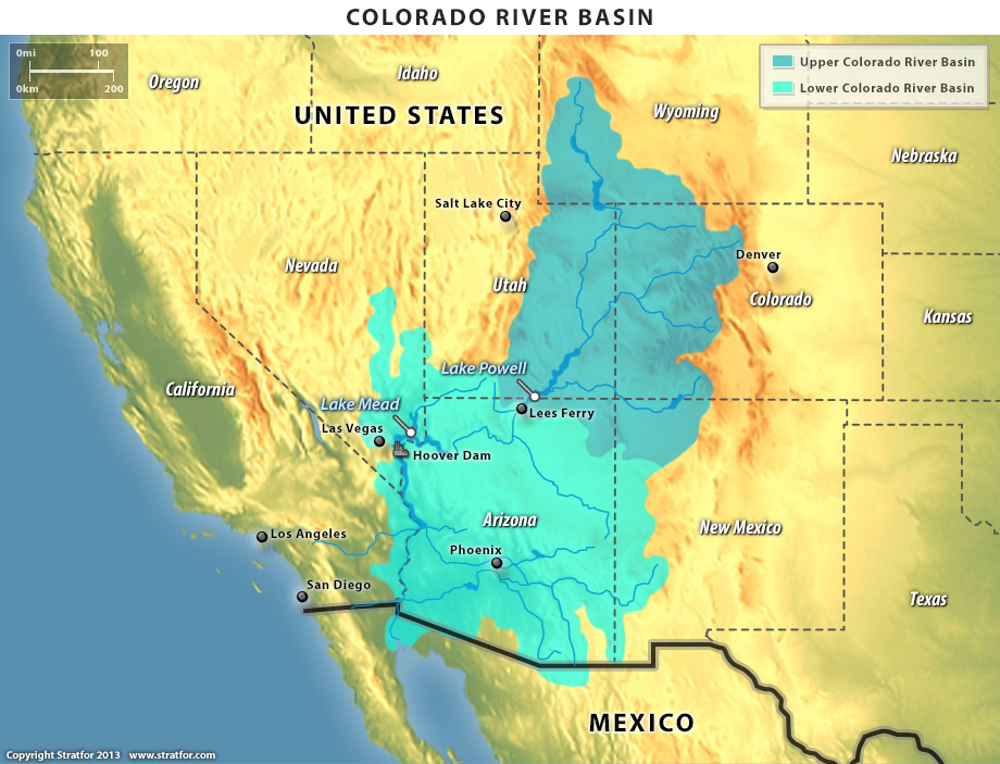
The Colorado river

Alternative stream management strategies
The responses to flooding are the results of development, knowledge, perception and characteristics of the flood and the success of the prediction.The responses are:
- Bearing the loss
- Emergency action
- Flood-proofing
- Flood control
- Land-use zoning
- Flood insurance
Flood embankments - it may raise flood level up and downstream
Channel enlargement - this channel is rerely used and it becomes clogged with weed
Flood relief channel - appropriate where it is impossible to modify the original channel
Intercepting channels - these channel are allowing flow for town and agriculture use
Removal of settlements - very expensive
Channel enlargement - this channel is rerely used and it becomes clogged with weed
Flood relief channel - appropriate where it is impossible to modify the original channel
Intercepting channels - these channel are allowing flow for town and agriculture use
Removal of settlements - very expensive
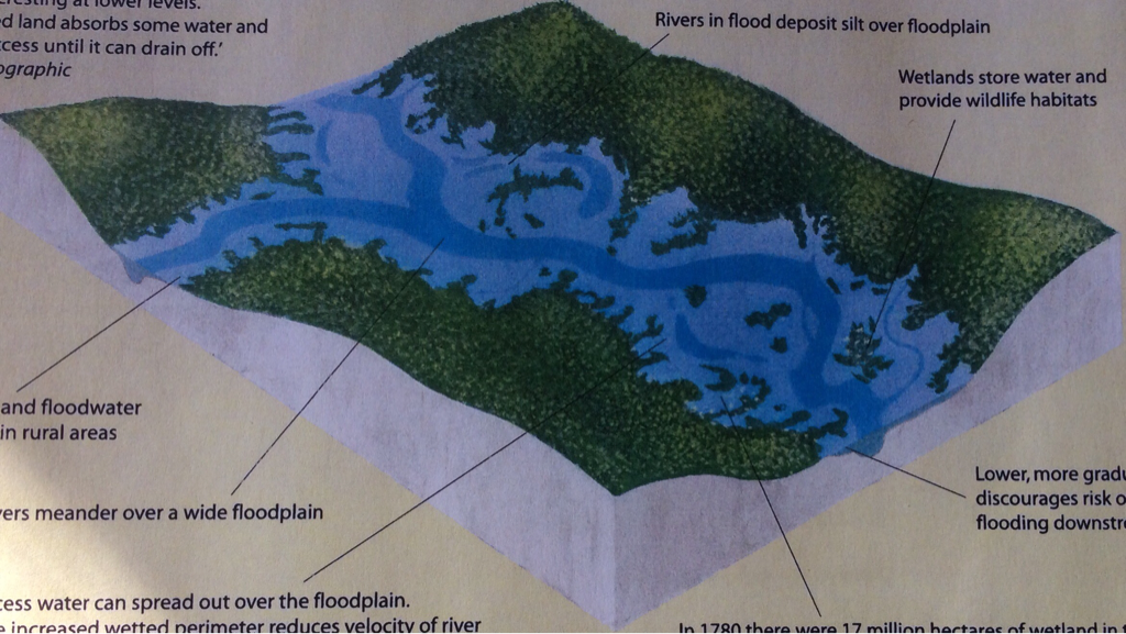
If river is unaltered by levées and asphalt, floodwaters can spread slowly depositing rich silt
and causing less erosion. Undeveloped lands absorbs some water and hold the excess
until it drain off.
Heavy rainfall and floodwater can be stored in rural areas and river meander over a floodplain. It deposit silt over floodplain. Excess water can spread over the floodplain.
and causing less erosion. Undeveloped lands absorbs some water and hold the excess
until it drain off.
Heavy rainfall and floodwater can be stored in rural areas and river meander over a floodplain. It deposit silt over floodplain. Excess water can spread over the floodplain.
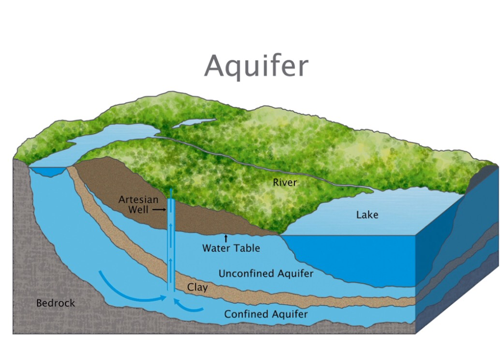
Groundwater
Groundwater is water which is contained within the pore and crevices of soils and rocks.
Phreatic zone is permanently saturated zone within solids rocks and sediments. Water table
is the upper layer. The water table varies and it depends of precipitation.
Aeration zone is wet and seasonally dry zone. Most groundwater is found within a few hundred metres of the surface but also has been found at the depth up to 4km. Groundwater
accounts for 96.5% of all freshwater on the earth. Groundwater may not be recycled for as
long as 20,000 years and it is a non-renewable resource.
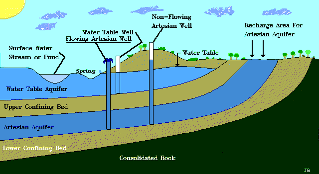
Aquifers: Rocks whihc contain a significant quantities of water providing water reservours underneath. Aquifers are permeable rocks such as sandstones and limestones. Aquiclude
is a rock which will not hold water.
is a rock which will not hold water.
Groundwater recharge occurs as a result of:
- Infiltration of part of the total precipitation at the ground surface
- Seepage through the banks and bed of surface water bodies such as rivers, lakes and oceans
- Groundwater leakage and inflow from adjecent aquicludes and aquifers
- Artificial recharge from irrigation and reservours
Losses of groundwater result from:
- Evapotranspiration particularly in low-lying areas where the water table is close to the ground surface
- Natural discharge by means of spring flow and seepage into surface water bodies
- Groundwater leakage and outflow through aquicludes and into adjecent aquifers
- Artificial abstraction
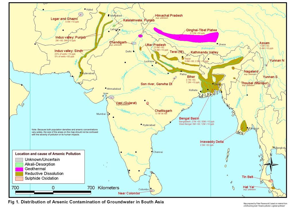
Case study: Groundwater pollution in Bangladesh
There has been a serious increase of cancers in Bangladesh. It has been caused by naturally occurring arsenic in groundwater pumped up through the tube wells. Estimates by Wolrd Health Organisation, 85 million people out of 125 million will be affected by arsenic-contaminated drinking water.
Millions of tube wells has sunk providing a comvenient supply of drinking water free from the bacterial contamination of surface water. That water was killing one-quarter of a million children a year. But the water from the wells was never tested for arsenic contamination. One in 10 people who drink the water containing arsenic will ultimately die of lung, bladder or skin cancer. Arsenic is tasteless,colourless and take in small doses in water has no immediate ill-effects.
The first cases of arsenic-induced skin lesions were identified across the Indian border in 1983.
Arsenic poisoning is a slow disease. Skin cancer occurs after 20 years of ingesting the poison. The real danger is internal cancer of lungs and bladder which are usually fatal. Bangladeshi doctors have been warmed to expect an epidemic of cancers by 2010. The people mostly affected will be between 30 and 40 years old. The global organization "Who" shows that arsenic-contaminated water is a global problem in Thailand, Taiwan, United States, Chile, Mexico, Chima, India and Bangladesh. One solution is collecting water by pipe from gutters. Monsoon in Bangladesh provides massive amounts of rain which have not tradicionally been collected for drinking. Other possible solution is filter using 3 cheramic pots suspended above each otherand a pump set up by a pond or river in which the pumped-up groundwater is filtered before emerging through a tap. Tube wells are easy to sink in the delta's soft alluvial soil and for ten of millions of peasants the wells have revolutionised access to water.
Freshwater wetland management
|
A wetland is a land area saturated with water. It can be permanently or seasonally. Wetlands have their own valuables such as characteristic and specific vegetation of aquatic plants. They are very adapted to its hydric soil. Wetlands have a massive role in the envioronment and they are controling floods. The water found in wetlands can be:
|

|
Importance of wetlands
- Wetlands prevent flooding by holding water much like a sponge. By doing so, wetlands help keep river levels normal and filter and purify the surface water.
- Wetlands also release vegetative matter into rivers, which helps feed fish in the rivers. Wetlands help to counter balance the human effect on rivers by rejuvenating them and surrounding ecosystems.
- Wetlands also clean the water by filtering out sedimentation, decomposing vegetative matter and converting chemicals into useable form.
- Wetlands are also known as popular touristic places because of their rich and protected vegetation and animals(flora and fauna).
Threats to these areas
- Urbanisation - As the world's population increase needs of water,food and space. In the fact of water, it means that wetlands will be drained for the benefits of people and their needs that would reduce the amount of water in wetlands. Fish and other species will be used as a food resource which would decrease and biodiversity in the river and cause problems. In fact of space, wetlands areas will be drained and inhabited. Housing and urbanisation are the main problems which would have a huge affect on the wetlands.
- Pollution - Huamans will bring pollution with them and it can be any kind of pollution included through chemicals and metals that will change the ecosystem of wetlands. Using pesticides for plants grow will have negative effects on the wetlands and surrounding land.
Case study: Kissimmee River - Florida U.S.A
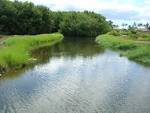
The Kissimmee river is located in central Florida with its originally length of about 216 km and 166 km of which was between Lake Kissimmee and Lake Okeechobee. It's floodplains reaches a width of up to 5km and supports a diverse comunity of waterfowl, wading birds, fish and other wildlife.
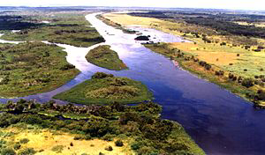
The Kissimmee river is located in central Florida with its originally length of about 216 km and 166 km of which was between Lake Kissimmee and Lake Okeechobee. It's floodplains reaches a width of up to 5km and supports a diverse community of waterfowl, wading birds, fish and other wildlife. In 1947 there was a terrible rainfall and it produced flooding all over the central and southern Florida. Florida requested assistance in controlling future floods and 1954 authorised the canalization of Kissimmee river. Between 60’s and 70’s Kissimmee river was shortened from 166km to 90km and also its channel has been dredged. That project damaged river in every way, firstly with the faster water flow and major environmental problems. Next step of management is to reverse the process and to re-introduce many oxbow lakes in the river that will slow down the water.
The problem related to the management of the Kissimmee river is flood. Kissimmee river has been shortened and narrowed. In 1926 there was the huge hurricane storm in Lake Okeechobee that killed about 2,500 people in that area. That was the strongest hurricane that killed more people than any other hurricane in the U.S. history. The goverment react and go in action of constructing an earthen levee that still surrounds lake's perimeter. Two hurricanes flooded the region in 1947. On the congress they made idea of flood management system that raised the height of the Hoover Dike. That progress was leading to further authorize the channelization of the Kissimmee river for flood control in 1954. Locks and dams along the river controlled flow into Lake Okeechobee. The 160m meandering river was replaced by the 90m long C-38 canal eliminating the seasonal flooding of the river's floodplain. That canal resulted the loss of the 40,000 acres of marsh floodplain and stimulated agriculture which harmed the quality of water flowing to Lake Okeechobee. Environmental impact of channeling were quickly recognised. Restoration project is repairing the river and its floodplain by increasing water storage in the Kissimmee Basin by removing two water control structures and floodplain levee.
The aim of the restoration was to restore the Kissimme river to its original flow. That was approved in congress in 1992 and began with modification in 1997. In 2006 the land along the river had acquired enough to complete resoration of 70 km of the Kissimmee river. Wildlife is returning to the restored section. When flooding and continuos flowing began again it would increase levels of the oxygen in water creating near. Perfect conditions for aquatic species. Fish population will boost and it will led to raise bird and alligator population. This is one of the reason why the Kissimmee river is restored and its biodiversity has risen up by 1997.
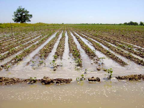
Irrigation and Agriculture
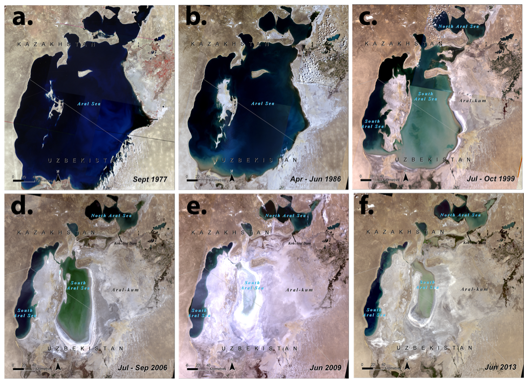
Case Study: Aral Sea
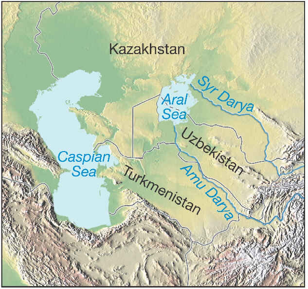
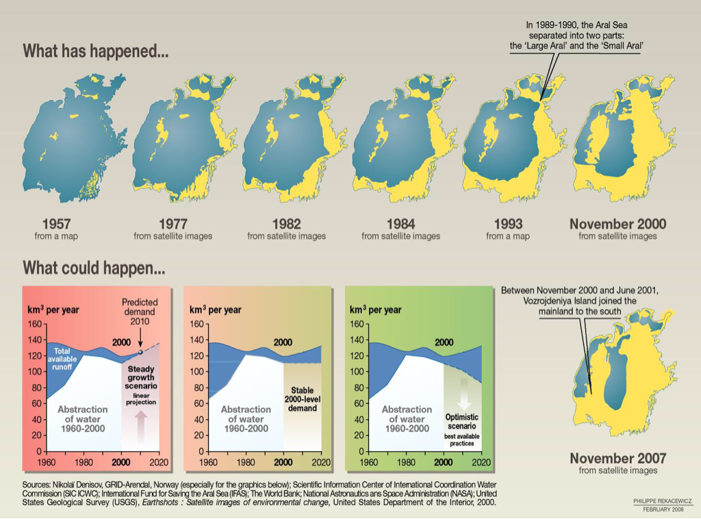
Aral sea is located in the Central Asia between Kazakhstan and Uzbekistan. Until 1960's, it was the world's fourth largest saline lake with 10g of salt per liter. It is supplied by two rivers, Amu Darya and Syr Darya. Suddenly, in the 1950's the Soviet government decided to use these 2 rivers in order to irrigate the desert region surrounding the sea because of agriculture rather than to supply Aral sea basin. The main reason was agriculture based on the cotton. Using so much water from the rivers without letting Aral sea to refresh and fill its basin caused big desertification. This is the process of making deserts by draining water from one particular area caused by humans. A huge amount of water in Aral sea disappeared in few decades.
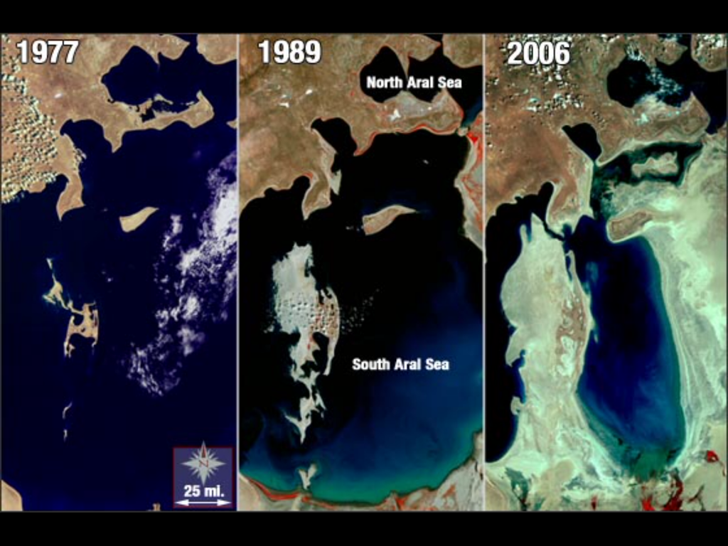
On the picture above, you can clearly see difference between the Aral sea through many years of irrigating deserts around the sea. The water from the sea started dramatically decreasing from the 1960's because Syr Darya and Amu Darya were used for irrigation. Only one fifth of the water supply Aral sea gets from the rainfall. Other four fifths are supplied by two big rivers, Syr and Amu Darya. The sea is not supplied with the same amount of water any more and evaporation cause the water level to decrease rapidly. Two big suppliers for the Aral sea were suddenly closed. It was a shock for the Aral sea to have loss of four fifths of its water supply.
Cotton production has three main negative effects:
- Consumes large amounts of water in furrow irrigation structure
- Requires more labor force due to the lack of financial capacity of farmers
- Pollutes water and the environment because of mixing used field water full with chemicals and fertilizers with river or drinkable underground water.
Desertification: The Aral sea experienced desertification during the short time period of few decades. It is characterised by degradation of the land and natural resources. Several factors influenced desertification including the decline in groundwater level. The hydrological balance of the area become offset as more water leave the region. The decline in the water of Syr Darya and Amu Darya deltas contributed salt to go on the surface. This increase in salt had a huge impact on vegetation and its vegetative cover of the environment near by. The plants started to die away and vegetation in the region was reduced by at least 40%. A side effect of the decrease in vegetation which was protection led to more dust storms. Six million hectars of agricultural land ware destroyed as a result of salinization and desertification.
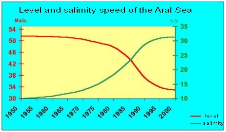
Salinization: A really quick increase of salinization of land is one of the most negative consequences of the Aral sea. Declining of the groundwater level caused the salt to accumulate in the subsoils which led to increase in led deposition in he soil profil which prevented anything from growing there. Salinization of soil accelerated desertification process. It was a sharp decline in groundwater which eventually led to soil erosion (one of the primary reasons for extensive fertilizer use). These fertilizing practices created pollution that went both into the Aral sea through groundwater circulation and into the air through dust storms.
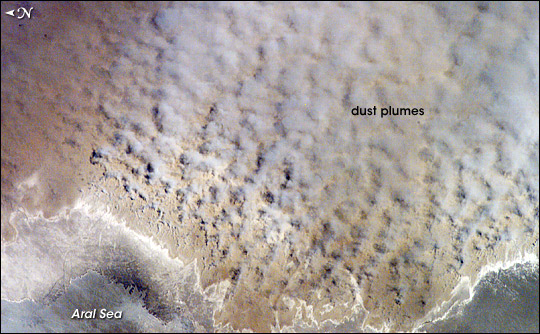
Dust storms: The number of dust and salt storms increased. Satellite images have revealed that there are up to 10 major dust storms occurring annually in the region (mostly between April and July). The loss of the sea meant that its protective action from the wind was significantly reduced. The receding sea left behind large amount of salt from the exposed sea bed. The strong winds now pick up the sand, salt and dust creating strong dust storms.
Future of the Aral sea: The first reaction of protection was in 1990's by local villagers. They managed to improvise dam made of sand allowing for the sea level in the Northern part of the Aral to stabilize. That dam did not withstand time and it had to be repaired or rebuilt. This dam was first effort made by local villagers which turned into a major project financed by the World Bank that is prepared to invest 85 million dollars. The aim of the project is to built a proper dam at the southern border of the Northern basin. The dam was finished in the summer of 2005. The water level in the "Little Aral" risen from 38.4m to 42m. Its surface grew by about a third within a year after the dam was built. The project is not at its end yet, and further improvements will soon come as a result of continued attention paid to water inefficiencies and depolluting the region from pesticides and other sources of soil and air degradation.
Demand for water: local/national scale
Water is one of the most sensitive and unsolvable problems in the Middle East which created friction between Arabs and Jews that cause Israeli - Palestinian tensions.
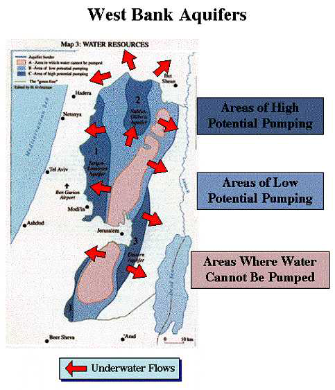
For decades Israel has obtained up to 80% of the 670m3 of water provided by the mountain aquifer that is located under the West Bank. The Israelis have occupied the West Bank since 1967 and have prevented the Palestinians from obtaining better access to the resource.
The mountain is important for Israel and it provides:
- One third of its water consumption
- 4 % of its drinking water
- 50 % of its agricultural water

Jewish settlers in the West Bank use about 60m3 whilst 1.5 million Arabs in the West Bank use about 137 million m3. The West Bank irrigate 70% of their cultivated land compared with just 6% of Palestinian land. The West Bank and Gaza are served by Israel's water carrier and groundwater region's aquifers. The West Bank aquifers replenished by the water on its hills flow west, north and east from the central drainage. The easter aquifer lies within the West Bank providing water for Palestinians and Israeli settlers. Its usefulness is tempered by the fact that the main population is centered in the center or to the west. Israel with its 5 million people consume three of four times as much water per head as the 2 million Palestinians. What is bad in the West Bank is usually worse in Gaza. The Gazans, like the West Bankers, get a little domestic water from Israel's national carrier. Most of their meagre supplies come from an aquifer that has been exploited and is in a badly dilapidated state. The Gazians pump out about twice as much as can be safely withdraw. Seawater creeps in making the water so saline that it kills the citrus trees.
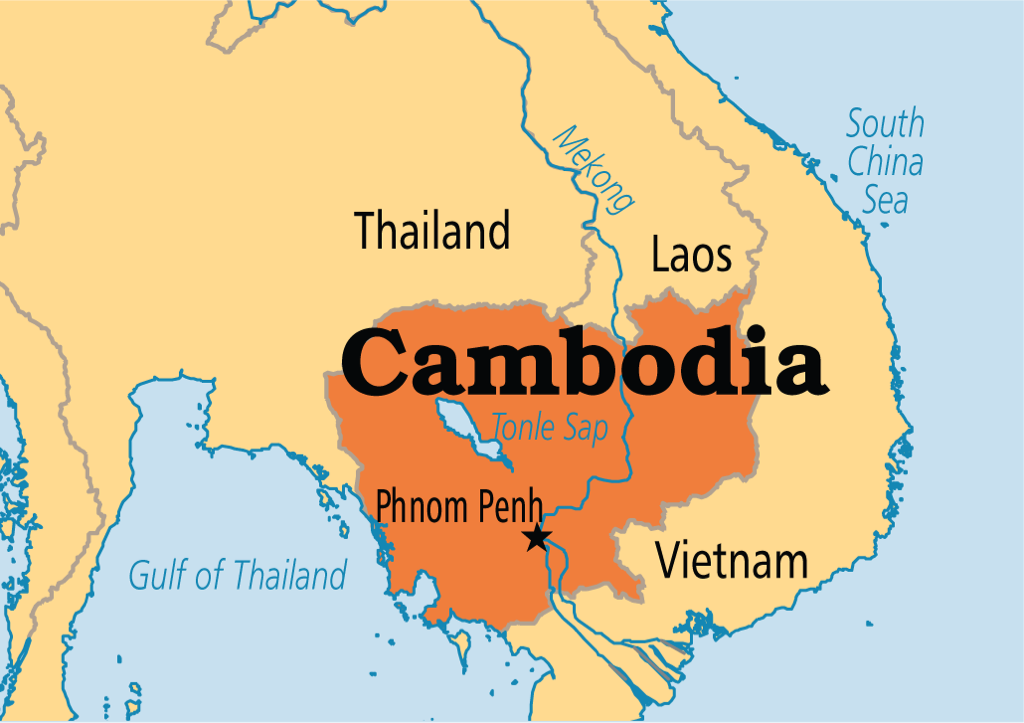
Case study: The Mekong
The Mekong is the largest river in the South-East Asia. It is the world's 12th longest and 21st in the size of its basin. The largest expanse of flat, well-watered and fertile land in the basin lies around Tonle Sap lake but the devastating annual flood makes intensive agriculture difficult there. The surface of the area can swell to up 10 times its normal size during the monsoon periods. The population along the course of the Mekong is limited. The largest city, Phenom Penh has just 1.1 million inhabitants which makes the river unusual in another respect (the burgeoning population and fast economic growth are only just beginning to make their mark). This massive river has been an economic backwater, remaining almost untouched until the 1990's. The first dam in China was not completed until 1993. The first bridge across the Lower Mekong was built in 1994. Population growth and economic growth are now creating a strain on the Mekong.
Dams along the Mekong: The hydroelectric potential of the Mekong and its tributaries is considerable and largely untapped. Early plans to develop the river failed to materialize due to war and civil unrest. Only 5% of the lower basin's hydroelectric potential of approximately 30,000 MW have been developed and few project have been on the tributaries. There is 13,000 MW potential in Laos, 2,200 MW on tributaries in Cambodia and 2,000 MW on tributaries in Vietnam. In the upper Mekong basin there is 23,000 MW potential. The dams generate valuable electricity, aid irrigation and regulate flooding. The impact on Mekong that dams caused is mostly on its fisheries. The Mekong and its tributaries yield more fish than any other river system. The annual harvest including fish farms is about 2 million tonnes. The Mekong is home to over 1,200 different species of fish - more than any other river.
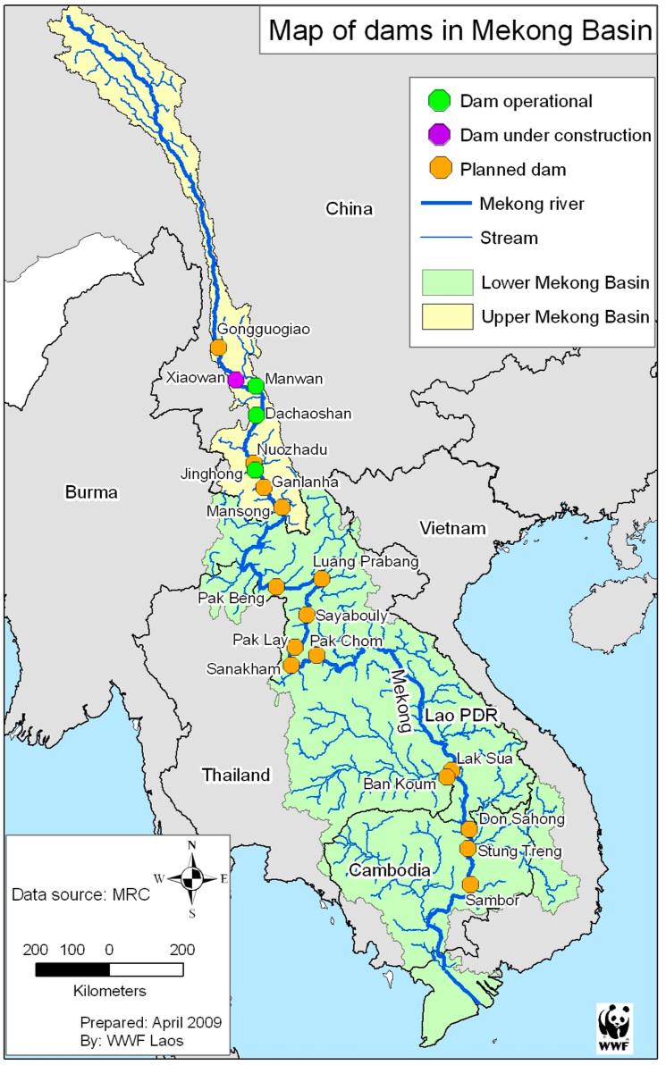
Case study: Cambodia
The cumulative impacts of the Mekong dams are likely to affect Cambodia significantly where the river's annual floods create the world's fourth largest catch of freshwater fish and employment for 1.5 million people. Cambodia catches 400,000 tonnes of freshwater fish a year, ranking it only behind China, India, Bangladesh, but annual river levels are thought to have dropped at least 12% since the dams and irrigation works started upstream. If the proposed 4 billion dam is built the situation could go worse. This is expected to flood 800km2 displacing 60,000 people and affecting fishing. Dams built by Vietnam and major Mekong tributary have been particularly damaging in Cambodia. About 80% of rice production in the Lower Mekong basin depends on water, silt and nutrients provided by the flooding of the Mekong. Dams on the Upper Mekong could mean less frequent floods, adversely affecting farming and fishing.